The Sacred Isle Of Iona
Extract From Phoenix Returns – 4th June 1999
“We have left you evidence of the teaching of one in the sanctuary of the island of Iona. The North West of Scotland was once the departure point for travellers to Atlantis. As the years went by this became neglected but the island is surrounded by natural harbours & under the water there is a series of carved stones that were once the ‘lintel’ pieces of a healing sanctuary in the area. You will find them laying on the sea bed, covered with thick mud. They can be raised and having been protected from weathering, the inscriptions will be intact and can be deciphered with reference to early Abyssinian language”.
http://www.atlantiswisdom.org/4th-June-1999.html
Willam Sharp writing under the pseudonym Fiona Macleod, said “To tell the story of Iona is to go back to God, and to end in God”.
A Brief History Of The Geology Of Iona and the Ice Age In Great Britain
Iona, also known as Druid’s isle/island is a place with a long and colourful history. Steeped in intrigue and mystery the island has drawn countless visitor’s and pilgrims to it’s shore’s over the many centurie’s of recorded history.” It is located in a part of Scotland in which the underlying geology truly dominates the landscape. Steep cliffs of lava, like those of Staffa, dominate northern Mull, while the high mountains of the south expose the roots of a huge volcano that erupted 60 million years ago”. Both the isle’s of Mull and Iona contain surface areas of lava thought to be from the volcanic eruption that was the largest eruption seen in north western Europe around 55-60 million years ago, which formed the continents as we see them today (to a degree).Therefore Mull and Iona are thought to be made up of some of the oldest rock’s on planet earth.
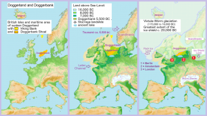
“It was between 29,000 to 14,700 years ago that the last widespread glaciation covered the whole of Scotand. “ After 14,700 years (12700 BC) ago the climate began to warm at a rapid rate with temperatures seemingly like we experience today, resulting in the melting of the glaciers and deposits of sand, minerals etc. “Between 12,500 and 11,500 years ago the last local glaciation occured in the mountains of Mull”. The coastline of Iona shows signs of changing sea levels due to ice melt in recent geological times, with much of the present day North Sea being dry land until 4000BC.
Ref – ‘ Mull & Iona – A landscape fashioned by geology’ – by David Stephens
In summary then Iona, a place I suspect may have had links going back to ancient civilization’s, possibly including Atlantis, was covered in ice 14,700 years ago (12,700BC) which abated for a period of approximatley 2,200 to 3,200 years, around 12,500 to 11,500 years ago (10,500 – 9,500 BC) giving any would be civilazation of that era plenty of time to adopt practice’s and create buildings etc. We now know through the discovery of Gobekli Tepe in Turkey that civilizations in and around that epoch were designing and building stone works that are more advanced than what we had previously believed.
Buildings/Structures of Iona – Past & Present
We know that Iona is home to a number of old building’s and stoneworks of various antiquity and from the evidence gathered it appears as though a number of these buildings are built on top of other,older structures, much in the same way as we find in other parts of the world, with church’s, temples, etc built on top of older sites. So in order to back up what I, myself suspect and what Sheelagh Donnely has written about (the first paragraph i this piece is an extract from her book ‘Phoenix Return’) we are looking for evidence of a building that would pre-date by several millenia, any of the existing stone buildings currently on Iona.
Perhaps the most famous of these building’s is the Abbey. The original Abbey of Iona was built in AD563 by a Irish monk called Columba (Irish: Colm Cille, or church dove) and was of relativley simple design and made of wattle and daub. Columba was a prince from a noble Irish family and arrived on the island accompanied by 12 people, having already established a number of monastic houses in Ireland. Alongside his colleagues Columba taught and spread the word of what is known as Celtic Christianity. The place they designed and constructed came to be known throughout the area as a place of learning, healing and hospitality. Columba and his monks, along with the island of Iona itself seem to have played a key role in the conversion of both the Scottish and the English people into Christianity. It’s original location though seems to have been, up until quite recently at least a bit of a mystery.
“For many years, the exact location of the original monastery, the one formed by St Columba around AD563, was cause for debate. After several excavations during the mid 20th century it was found to be partly underneath the medieval abbey. The Vallum (a defensive wall, or stockade-my notes) which formed the boundary of the early monastery is the best preserved part of the early remains. Early accounts suggest that it would have been built at the foundation of the site. It wasn’t until 1772 that features older than the medieval building began to be noted. The structures would have been more temporary as described in Adomnan’s (an abbot of Iona abbey AD679-704 – my notes) ‘Life of Columba’. Most of the evidence of these has been destroyed by farming”. Could this be the site of the old Druid’s temple Columba is thought to have settled in upon his arrival in Scotland? It would make sense that Columba built his original monastery on top of a pre existing stone structure and possibly used the same structure’s foundations, stone work etc to help with the task. There are countless examples of such buildings scattered around the globe being constructed on top of older, sacred sites.
https://canmore.org.uk/collection/372935
“Limited archaeological investigations of the enclosure suggest that one of the outer banks (of the Abbey) on the west side may have been built before the arrival of Columba”.
http://portal.historicenvironment.scot/designation/SM12968
The abbey we see today was built on or around the the site of Columba’s original monastery by a Viking named Raghnall (also known as Ranald) in 1200AD as a centre for Benedictine worship. In 1203AD Raghnall invited the Benedictine order to establish a new monastery, and a Augustinian nunnery on the previous Columban monastery foundations.
Over the years the building fell into decline and ruin and was restored by Reverend George Macleod and the newly formed Iona community in 1938, into the Abbey we see today.
Stone Pillars Of Iona
The following are extract’s from a book written by Godfrey Higgins (published 1836) called ‘Anaclypsis an attempt to draw aside the veil of the saitic isis; or, an inquiry into the origin of language’s, nations and religions’ – page 401-402;
” The temple in the sacred isle of Iune or Iona of the west was surrounded with 360 stones but within the larger circle it had a smaller one of 60 stone crosses and close to it the island of Linga”.
Higgins states that ” The word Caaba (the building at the most sacred site in Islam – Mecca – my note) was derived from the last part of the word Mercavah or Mercaba (Merkabah; Mer = Light, Ka = Spirit, Ba = Body -my note) from the noun Recab. It was the temple of the cabalistic cycle or circle of the sun or the heavens, the temple of Recab. For this reason it had a stone circle around it, and the black stone in the inside of the circle is still adored as the emblem of the sun, the generative principle. Originally it had a dove or Iune, as an object of adoration, said to have been destroyed by Mohammed himself”. Interestingly the Irish translation of the name Columba is Dove, St Columba as previously stated is synomonous with the island of Iona or as it was also once known as according to Higgins, “Iune”.
He goes on to say that ” a temple was the circle or wheel of the heavens. The Caaba with it’s 360 pillars around it, was the temple of Mohammed (like the temple of Solomon) or circle, or wheel of Mohammed. All the oldest temple’s of Zooraster and the Indians were caves, acknowledeged to be in imitation of the vault or circle or wheel of heaven”.
He adds further ; “Every temple was a microcosm of the Universe. In immitation of this the temples were surrounded with pillars. The temple of Mecca had 360. The temple of Iona had 360 in the outer circle, and 60 in the inner one, wheel within wheel and three revolving globes.”
In ‘Morals and Dogma: Scotish rite in Freemasonry by Albert Pike, he describes that; “all temples were surrounded by pillars, recording the number of the constellations, the signs of the Zodiac, or the cycles of the planets, and each was a microcosm or symbol of the Universe having for roof or ceiling the starred vault of heaven”.
“All temples were originally open at the top, having for roof the sky. Twelve pillars described the belt of the Zodiac. Whatever the number of pillars they were mystical everywhere”.
“The theatre built by Scaurus, in Greece, was surrounded by 360 columns, the temple at Mecca and that at Iona in Scotland by 360 stones”.
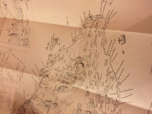
In a recording of two gentlemen discussing the old names of Iona from the website ‘Tobar an Dualchais.co.uk (see the link below, between 30minutes and 33 minutes in), one of the men, Dugald MacArthur suggests that one of the location’s on the map they are talking about has two names. The map in question was by Alec Ritchie, and the alternative name given by MacArthur for one of the Glen’s , is Glen on Temple, and he goes on to say “there’s supposed to have been a temple buried there at one time”. He then goes on to say that an area near this region is “one of those grey areas of Iona”, “it’s very difficult to identify, it’s never been dug out you see, there aren’t any remains on the surface. It’s supposed to have been one of those places that un-baptised children were buried”.
http://www.tobarandualchais.co.uk/en/fullrecord/84012/7;jsessionid=71870870B0FF22F6178FFDAB86D45071
Another old map of Iona gives the name ‘Temple Glen’ for the region of the island which MacArthur states has an alternative name of “Glen on Temple”.
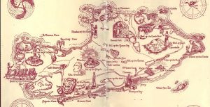
“Glen an Teampull lies around the middle of the island. It is believed to be the site of the monastery which was erected by the Benedectine monks on their taking possession of Iona. Their was an old burial ground at the head of the glen, but no traces of it remain”.
http://www.electricscotland.com/history/iona/chapter08.htm
On page 11 of Ritchie’s book we find the following passage; “There is no authority for the statement (unfortunately repeated in one guide book after another) at one time there were 360 standing crosses in Iona, many of them having been broken and thrown into the sound”.
So it seems as though there are many references to the island once being home to a temple, and also having objects now thought to be pagan or un-christian like, broken and scattered into the sea, as suggested by Sheelagh Donnelly’s work in Phoenix Returns.
There is a case to be heard “that there were ever as many as 360 standing crosses, however, subsequently thrown down by frenzied church reformers in the 16th century is highly unlikely”, as pointed out by E. Mairi MacArthur in her book Columba’s Island – Iona From Past To Present. She says that ” the evidence for and against this (the island having 360 stone crosses) was weighed in an article by J.R.N MacPhail for the Scotish historical review 1925. He pointed out that the figure must derive from a conflation of two remarks made by William Sacheverell, governor of man, who visited Iona in 1688. These were, first that a note of 300 stones with inscriptions was in the possession of the Reverend Farquhar Fraser, dean of the isles from 1653 to 1680, and secondly that the Synod of Argyll allegedly ordered 60 crosses to be cast into the sea”.
“An act was indeed passed by the general assembly of 1640 that ‘Idolatrous monuments be demolished, especially in the north of Scotland, and there was subsequently an expedition through the isles for that purpose led by the Marquess of Argyll”…… “the shorthand of ‘360 crosses destroyed’ crept into print astonishingly quickly. Dean Fraser’s own son John included it in his reply to Sir Robert Sibbald seeking material for MacFarlane’s geographical collections of 1693. It has been repeated time and again since”.
Standing Stones/Markers Of Mull
It would also seem as though the island of Mull across the sound from Iona was once home to upright standing stones possibly put there for would be pilgrims to find their way to the island. On page 5 of ‘Columba’s Island – Iona from past to present’ E.Maire MacArthur says “In the proceedings of the society of antiquaries of Scotland for 1863 the Reverend Thomas Maclaughlan claimed to have noted an entire series of standing stones leading along the Ross of Mull. Upon enquiring of the local minister, the Revd Donald McVean found that ‘Tradition is uniform among the natives, that they were intended as guide posts to strangers visiting Iona on pilgrimage’. Having been erected before the time of Christ, one can only assume there must have been a reason for people to visit Iona before the Christian era and that enough people would cross the land instead of the sea to make the task worth while.
Interestingly, the remains of 48 King’s of Scotland, 8 King’s of Norway and 4 from Ireland lay at rest in the hallowed soil of Iona. According to Ritchie this was “because it was the most honorable place that was in Scotland in those days”. (Original quote is in Olde English made by Dean Munro who visited Iona in 1549 – Ritchies book p9)
Cladh An Disert
There is a region to the East of the Abbey that is known as, ‘Cladh An Disert’ (Cladh can be translated as ‘Stone’ and Disirt as ‘Desert’) and it seems to be generally agreed now that this is the area in which Columba built his original monastery, and that the stone Blathnat , a huge red granite stone left by the melting ice cap’s marks it’s former Northern limit . It is thought that the area of the original monastery containing this stone was the refectory, and that any food placed on it at the time would become blessed.
“Cladh An Disirt” – “burial ground of the hermitage” or “Cladh Iain” – “John’s burial ground” is an enclosure about 20 yards square, at the west corner of which are two upright granite stones about four metres high, evidently the gate posts of an enclosure. A third stone about three metres high adjoined on the north. Within the enclosure were the remains of a building, possibly the remains of a rude stone oratory”.
https://canmore.org.uk/site/21666/iona-cladh-an-disearthttps://canmore.org.uk/collection/376637
“In 1880 excavators discovered here the foundation of a hermit’s cell of the oblong type, 26 feet by 17, facing due east, and having traces of an alter piece at the east end (the sun of course rises in the East and many if not most temple’s/church’s etc have entrances facing east – my note.) These ‘disarts’ or hermitage’s were built sometimes in solitary places, sometimes in the neighbourhood of a monastery. The hermits spent their time chiefly in prayer and contemplation, and were frequently sought as spiritual advisers. They studied also, and worked at handicrafts like other monks. A hermit was usually buried in or near his cell”.
http://www.electricscotland.com/history/iona/chapter08.htm
The area of Cladh An Disirt contains a huge embankment that runs for hundreds if not thousands of metres across this region of the island and recent excavations have found it now reaches as far as away from Cladh An Disirt as the modern day school on Iona.
“The Vallum/Vellum or rampart was an normal feature of an early Irish monastery and formed it’s legal and symbolic boundary. At Iona it took the form of a rectiliniar earthwork enclosing an area of at least 20 acres, within which the principle buildings of the monastery (now superceded by those of the modern Abbey we see today) occupied a more or less central posistion. The alignments of other buried ditches, extending as far south as the Saint Columba hotel are known from aerial and geophysical survey and from excavation”.
Ref; Iona – A guide to the monuments
At present the vallum is dated to aound 700 – 800 AD, but carbon dating samples taken from it’s base have given dates stretching back as far as 200BC, well before the arrival of St Columba, see the quote below taken from Geoff Holder’s book ‘The guide to mysterious Iona and Staffa’ ; “Photographs and excavations show that the vallum is complex and built over more than one period although the mightiest surprise came from an excavation in 1988, radio carbon date from the peaty top soil beneath the bank a date for 100-200 AD, several hundred years bewfore Columba arrived. What was here before and who was building it?”.
https://canmore.org.uk/collection/371897 – Aerial photo showing the Vallum
https://canmore.org.uk/collection/372939 – View of the Vallum today as earthen embankments.
https://canmore.org.uk/collection/1450838 – View of the Vallum today as earthen embankments.
An interesting side note to this is that there is a modern day house in the region of Cladh An Disirt that is marked on Ritchie’s map as ‘Clacanach’, which can be translated as ‘the stones’ in Gaelic. This house marks the western boundary of the site. The name ‘Clachan’ is still given in the highlands to the place where a church stands in place of what was once a Druidical temple. The area behind the house was once covered in oak trees, and the hill located north of the area marked Clacanach on Ritchies map as Cnoc Daraich transaltes to ‘Hill of the Oaks’, the Oak tree being sacred to the Druids. This area of the island is thought to be where Saint Columba erected his monastery over 1300 years ago and “the section between the mill stream and clachanach may, it is thought, be partly natural or perhaps a pre-historic bit of fortification”.
http://sacredconnections.co.uk/index.php/iona-sacred-isle/http://www.electricscotland.com/history/iona/chapter08.htm
https://canmore.org.uk/site/21666/iona-cladh-an-diseart